Track, Measure, Verify with S2E Cloud

Track site evolution with temporal accuracy. Compare "As-Built" drone data against "As-Designed" CAD models to identify bottlenecks early.

Intelligent Construction Monitoring

Empower your project management with drone-based visual data, synchronized timelines, and automated progress tracking.

Construction Progress Loop Construction Progress Loop
Construction Intelligence
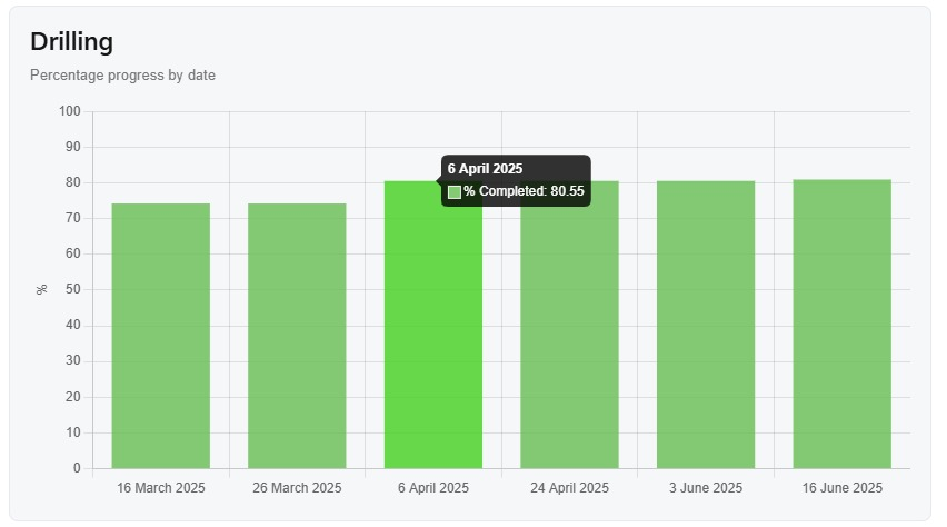
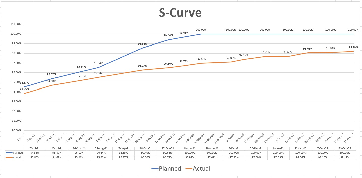
S-Curve

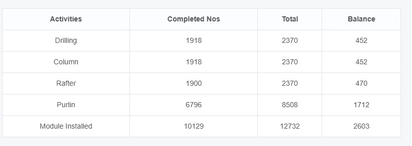
Track project performance with data-driven insights. Our S-Curve visualization helps stakeholders monitor planned vs actual progress over time, enabling better forecasting, early risk detection, and informed decision-making.

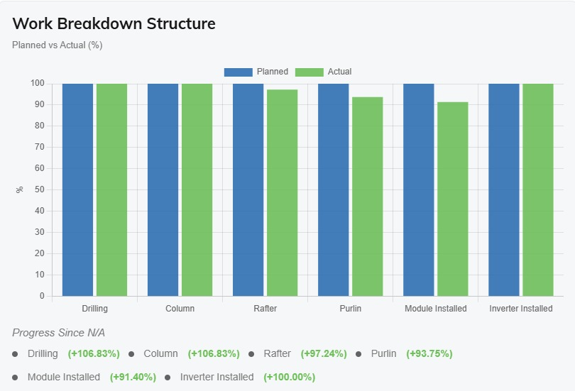
  • Timeline Analyze cumulative progress trends and compare planned versus actual performance.
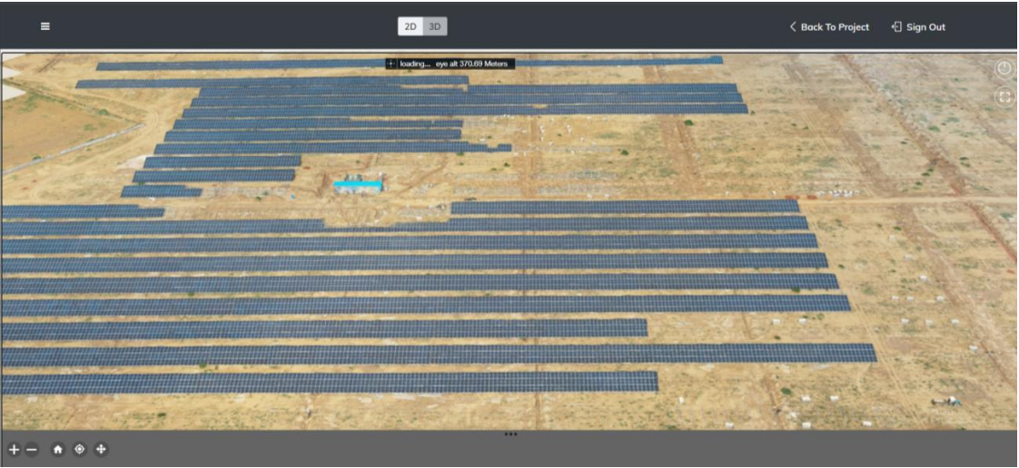
  • Team Collaboration Centralized cloud platform for seamless team coordination and data sharing.
Construction Progress Construction Progress Construction Progress Construction Progress
Execution Verification

Construction Activity Monitoring

From drilling and piling to MMS and module installation, monitor every stage of construction with clarity. Track real-time progress and ensure execution stays aligned with the plan.

  • Site Visualization View high-fidelity, up-to-date aerial maps of the entire construction zone.
  • Actual Completed v/s Pending Instantly quantify the difference between finished infrastructure and remaining work.
  • Side-by-Side Comparison Split-screen interface to compare current site conditions against historical dates.
Construction Progress Construction Progress Construction Progress Construction Progress
Browser-Based Analysis

Data Insights

Analyze progress with synchronized side-by-side comparison. Move through one view and the other mirrors it instantly—making it easy to spot deviations.

  • Overall Activity Tracking Quickly identify differences between planned vs actual across different timelines.
  • Individual Activity Tracking Drill down into specific tasks to monitor the exact completion status of individual assets like single piles, trenches, or modules to pinpoint localized delays.
  • Executed Quantity Extract exact measurement metrics to justify contractor payouts and supply orders.
3D Point Cloud Model
True Visualization

Drone Videography

Create a perfect digital replica of your active site. We generate dense point clouds containing millions of data points for virtual site walks and marketing updates.

  • Top-View Linear Video Smooth, high-altitude flyovers to provide an executive summary of site progress.
  • 360° Video Immersive imagery allowing remote teams to look in any direction from a specific waypoint.
  • Marketing Video High-quality cinematic footage perfect for investor relations and public updates.

Why Choose Sky2Earth Construction Monitoring?

01

Objective Visual Evidence

Eliminate contractor disputes with unalterable, date-stamped visual data. Ensure all stakeholders are perfectly aligned on actual site progress.

02

Detect Deviations Instantly

Overlay 'As-Built' drone maps against 'As-Designed' BIM/CAD models to catch structural errors early, preventing extremely expensive rework.

03

Remote Site Management

Allow investors, owners, and remote teams globally to walk the site virtually and track timelines without needing expensive software or frequent travel.

04

Actionable Metric Extraction

Go beyond simple photography. Extract exact cut/fill volumes and distance measurements to accurately justify contractor payouts and verify material deliveries.

Construction Site Drone Monitoring

Ready to transform your data?

From 45MW solar plants to complex mining sites, get the visual intelligence you need.